
See where I went with on-line electronic maps!
I love maps. So I have rather gone to town in providing maps of various sorts on this website. I’ve also provided electronic versions of my routes (see the “GPX” page) if you’d like to download all or part of my journey for your own personal use.
So here are the four ways to get maps:
![]()
1) High-level, low resolution overview of my route 
Click here to go to the bottom of this page to see a high-level route overview
![]()
2) Detailed, zoomable, high-resolution interactive map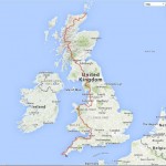
Click here to get to a map which will display my exact route on a variety of different background maps, including a satellite view. Two versions are available – a low resolution map (which will load quickly) and one with a high resolution, which will load more slowly
![]()
3) Interactive map with links to daily blogs
Click here to see an interactive map which will allow you to click on each day’s progress to read the blog, see the photos, and download an electronic file from that day
![]()
4) Daily walk maps
Click here to jump to the “daily blog” page – you can view the day’s track in exact, step-by-step, detail by clicking on the blue word “MAP” at the left hand side
![]()
Route overview
The map below shows an overview of my route, including where I was, and when. If you want to know more, check out the “Statistics” page or e-mail me for more info.
(Click the map to show a list of locations and dates in text format)
